
These maps were scanned from a 1950 USGS map. They show the incredible density
of the railroads in the Buffalo area prior to 1950. It's no surprise that
during the early years of the 20th Century Buffalo was second only to Chicago
in rail traffic.
About 85% of the track on these maps is gone. Outrageous City of Buffalo taxes
helped to drive the railroads into a "scorched earth" policy where they
removed or demolished everything possible from 1955 to 2000. Oh to be able to
go back 50 years for just one day of railfanning!
Additional Buffalo area map snippets with accompanying aerial photos and descriptions
are also at
nyc.railfan.net/buffalo
- Henry
Thumbnail Page for Directory 1950usgs
 |
1950 Western New York US Geological Survey Map
This map shows most of the railroad trackage on the east side of Buffalo. The yard at the upper right was the NYC East Buffalo Yard which became Frontier Yard. The yard at the middle right was the DL&W East Buffalo Yard which became Bison Yard, was dismantled in the early 80's and then partially rebuilt in the 90's by Norfolk Southern. The yard at the lower middle left was the Erie's East Buffalo Yard which became SK yard and a portion if this is still in use by CP and NS. At the upper middle left is NYC's Central Terminal which still stands, is not used and has lost 95% of its trackage. To it's right across the main line is NYC's East Buffalo Stockyards. At the lower left is the Lehigh Valley's East Buffalo Yard and DM Interlocking where the PRR and DL&W interchanged and the LV crossed on an overpass. All LV trackage shown is long gone. image/jpeg, 2035x1242 (256c) File="bison50.jpg" Size=848793 |
 |
1950 Western New York US Geological Survey Map
In order from top to bottom on the left, all NYC: Stockyards, Tower T Interlocking, Tower 48 Interlocking, Central Terminal, Tower 49 Interlocking, Tower 49A Interlocking and Tower 50 Interlocking. In order from top to bottom on the right: Erie's East Buffalo Yard, Tower FW Interlocking, Erie's trackage to Downtown Buffalo and to the right their trackage to the Katherine Street industrial yards. FW Interlocking: top to bottom is Erie, left to right is Buffalo Creek RR and upper right to lower middle is PRR with their Babcock St. Yard just to the upper right of FW Interlocking. FW is no longer an interlocking point for CSX and NS. Just below Smith and Seneca Sts. the Erie RR had a sizable shop complex which was dismantled in the first half of the 1900's. At the middle bottom is trackage owned from right to left: PRR, NYC, Erie, NYC and LV. image/gif, 1350x1756 (16c) File="cterm50.gif" Size=726926 |
 |
1950 Western New York US Geological Survey Map
From top to bottom: Buffalo Creek connection to the NYC (center top), FW Interlocking, NKP yard, Buffalo River drawbridges and Buffalo Junction Yards. The Lehigh Valley passenger main to downtown passed overhead parallel to Perry St. The DL&W passenger main to downtown passed overhead just above the Buffalo River drawbridges. Buffalo Creek owned the right (east) bridge and the Nickel Plate owned the left (west) bridge. The Buffalo Creek bridge is still in use today by CSX and NS and is known as as CP DRAW. image/gif, 563x1200 (16c) File="draw50.gif" Size=154945 |
 |
1950 Western New York US Geological Survey Map
This one is impossible to describe in any understandable way. Check HERE for a labeled map of the downtown station area. (viewed at a different angle) The DL&W coal docks are at bottom left below their downtown terminal at the foot of Main St. Buffalo Creek's Ohio Street Yards grain elevator trackage is across the river from the DL&W Terminal pon both sides of the West Channel. The New York Central main crosses the Buffalo River on a double track bascule bridge at the upper right, just to the left of the elevated DL&W passenger main. 95% of all this trackage is gone today, driven away by outrageous city of Buffalo property taxes on every piece of track, every signal and every railroad owned structure. image/jpeg, 800x1173 (256c) File="dtbuff50.jpg" Size=302739 |
 |
1950 Western New York US Geological Survey Map
Central Terminal is at the upper left. Downtown Buffalo is at the middle left. Erie's E. Buffalo Yard is at the middle right. FW Interlocking is the right center. PRR's Babcock St. Yard is at center right. NKP and Buffalo Creek yards run between Seneca St. and the Buffalo River. Buffalo Creek's (owned then by the Erie and LV) Ohio St. Yards serving the grain elevators and mills are at the lower left. The yards at bottom center from left to right are: LV, NYC, Erie, NKP and DL&W. image/jpeg, 1192x1676 (256c) File="dtbuffs50.jpg" Size=661117 |
 |
1950 Western New York US Geological Survey Map
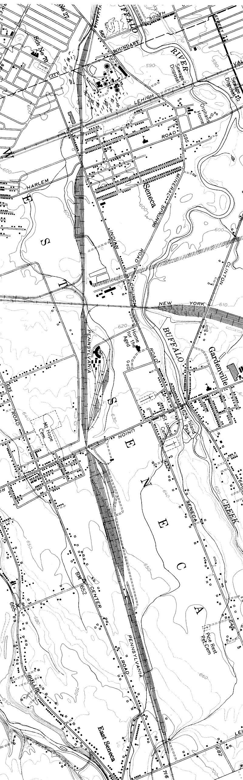
PRR's Ebeneezer Yard. PRR's Babcock St. Yard, DM Interlocking and Downtown Buffalo is off the map to the top. This is actually 3 different PPR yards. The small yard at the top is Mineral Springs Yard. The middle yard with the top leg of the wye is Ebeneezer Junction Yard. (Junction with the NYC Gardenville line) The two yards at the bottom are Ebeneezer Yard proper. All of Pennsy's yards are gone today, but the main still goes through to where DM Interlocking and FW Interlocking were, but most trains use the connection to the left to reach CSX' Seneca Yard. Conrail, NS and CSX call this connection GJ, obviously for Gardenville Junction, but I have not been able to find out if Central men called it Ebeneezer Junction or Gardenville Junction. New York Central's Gardenville Yard is to the right. The yard was removed in the 50's and the Gardenville Cutoff, much ballyhooed when built in the late 1880's, was downgraded and dismantled. The PRR roundhouse still stands today, in use by a freight car rebuilder, Eastern Railway Supply. image/jpeg, 800x2562 (256c) File="eben50.jpg" Size=525297 |
 |
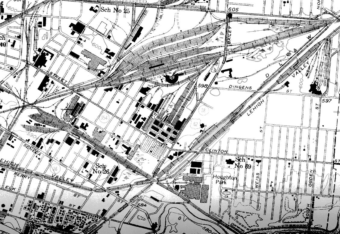
1950 Western New York US Geological Survey Map
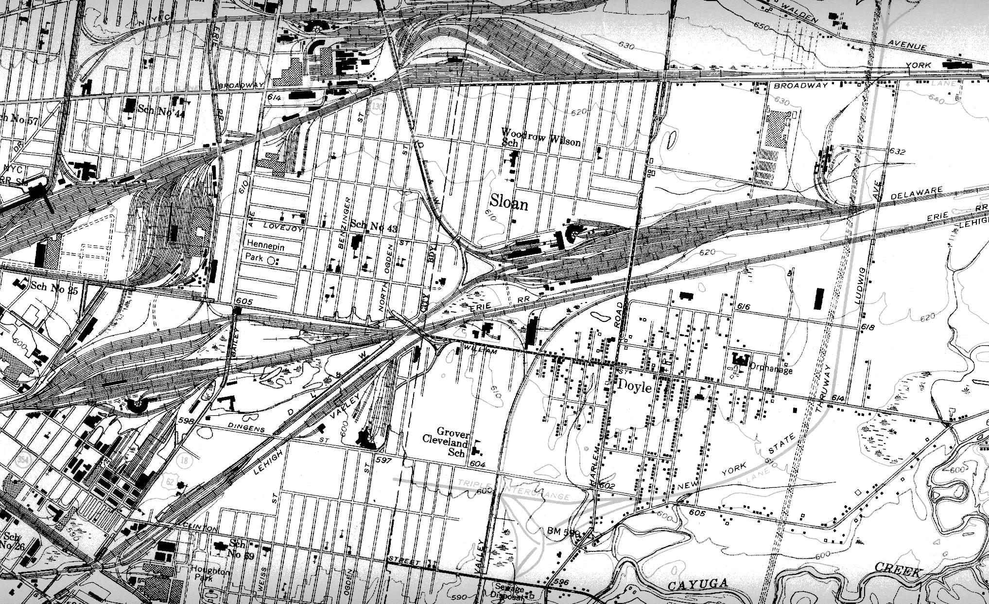
Most of the trackage shown here has been discussed above. The yard to far right is NYC's East Buffalo Yard and their West Shore Yard, later combined into the automated Frontier Yard. The lower Lehigh Valley line branching off the main line at Tifft Junction went to their Tifft Yard complex, Buffalo Creek's Ohio St. Yards and the LV's lake Erie coal docks. All Lehigh Valley trackage shown here is long gone, abandoned shortly after Con rail was created. The upper LV line went to their downtown terminal at Main and Scott Sts. It was dismantled in the late 1950's so the downtown section of the New York State Thruway could be built. NYS paid for LV's short lived Dingens St. Terminal at Dingens and Weiss St s. on this map. Both DL&W lines wyeing off their E. Buffalo Yard are gone, dismantled in the early 80's as part of Conrail's "Scorched Earth" policy which removed all the EL's bridges on the line to Black Rock so that right of way could not be used by any competitor. That was done while the government still owned Conrail! Certainly in the public's best interests, wouldn't you say? image/gif, 1404x2760 (16c) File="ebuff50.gif" Size=1288306 |
 |
1950 Western New York US Geological Survey Map
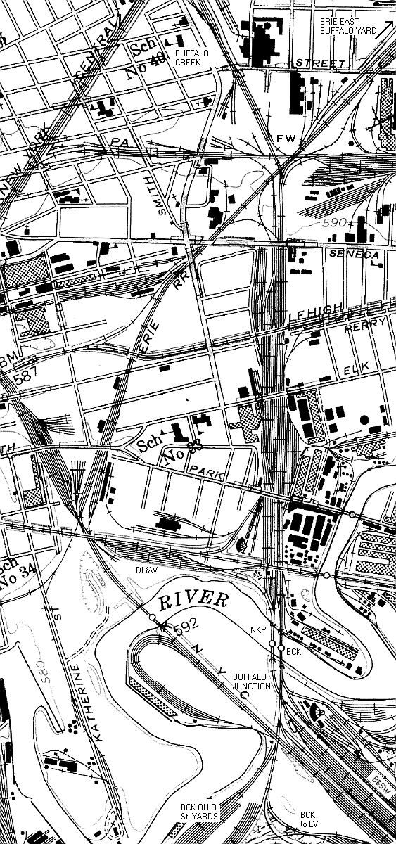
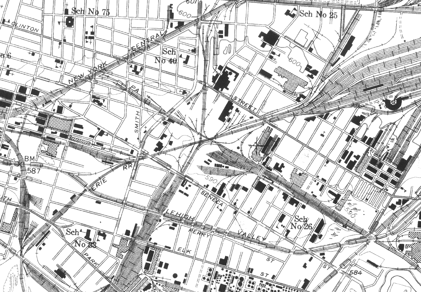
This map shows the Erie's East Buffalo Yard complex. At left center is FW Interlocking. Below and to the right of that is DM Interlocking. Top left is Buffalo Creek's connection to the NYC near Tower 49 Interlocking. PRR's Babcock St. Yard is between FW and DM. The DL&W "City Branch" crossed the PRR at DM. The LV crossed over both on a grade separated embankment. To the upper right is LV's East Buffalo Yard and engine facility. All of the DL&W and LV trackage here is gone today. only about 15% of Erie's E. Buffalo Yard remains, in use by CP and NS. FW and DM are gone. The PRR is single track from GJ to the "Transisco Wye" which was where FW was. image/jpeg, 1129x779 (256c) File="erie-eb50.jpg" Size=331921 |
 |
1950 Western New York US Geological Survey Map
FW Interlocking and surrounding trackage. The Erie's E. Buffalo yard is to the right. The PRR's connection to the NYC and PRR's downtown trackage is at Tower 49A Interlocking at the upper left. The Nickel Plate and Buffalo Creek yards at the bottom, just left of center. As a young teenager in the mid-70's I used to visit FW Tower. Check HERE for a more detailed description of FW and small labeled map of the FW Tower area. image/gif, 1442x1000 (16c) File="fw50.gif" Size=308219 |
 |
1950 Western New York US Geological Survey Map
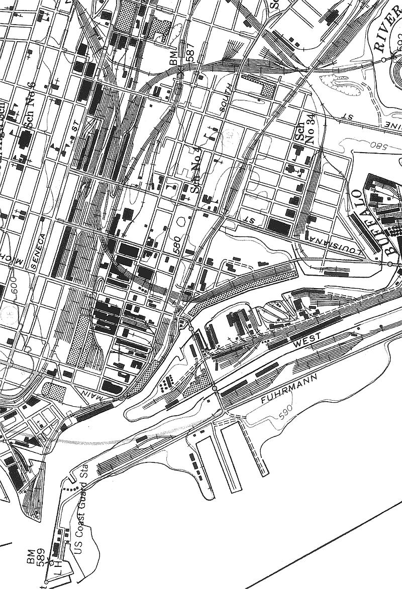
This map covers the NYC East Buffalo and West Shore Yards. The New York, West Shore & Buffalo was aquired by the NYC when J.P. Morgan got tired of the NYC and PRR's war games in the late 1800's and told them to play nice or ELSE! The West Shore main line runs east at the upper left. It is no longer used, but most of it remains intact. The old NYC main runs left to right at the bottom, it is CSX' Chicago main today. Tower 47 at the extreme lower left and tower 46 was the square dot at the bottom center below the engine facility. The DL&W Black Rock Branch crossed over the left end of the yard and the Erie's Niagara Falls Branch crossed over the NYC and West Shore mains a half mile to the west. Both are gone today save for the northern stub of the Erie which is used to service Am erican Axle Delavan Plant. Where the Erie crossed to the left of the Sycamore Wye is now called "Phantom Bridge." Tower T is just off the map to the lower left on the Belt Line. The NYC Stock Yards is just off the map at bottom center past Tower 47. The West Shore roundhouse and engine facility is directly in the center of the map. The quarter roundhouse below was the NYC's and survives today as a storage facility for a local construction company. The car shops below that (and the NYC roundhouse) were owned by Pullman. Aside from the NYC roundhouse, none of those buildings or tracks remain today. In the mid-50's when NYC rebuilt the E. Buffalo Yard into Frontier Yard it was touted at the most modern freight yard in the world. Aside from the NYC and West Shore mains, the arrangement of the yard is completely different today. Frontier Yard is CSX' main Buffalo area classification yard today. image/jpeg, 2226x714 (256c) File="fyard50.jpg" Size=403718 |
 |
1950 Western New York US Geological Survey Map
Gardenville Yard was built as part of the NYC's Gardenville Cutoff project to bypass downtown Buffalo in the mid-1880's. This sprawling facility and the cutoff itself was made obsolete by the construction Frontier Yard at the site of NYC's E. Buffalo Yard and numerous grade crossing eliminations on the mainline through Buffalo. Ebeneezer Junction with the PRR is to the left and to the right the cutoff crosses under the LV, Erie and DL&W, respectively. My father recalled seeing many Hudsons in the dead-line at Gardenville in the early 1950's. There seems to be very little in the way of information or photos of Gardenville Yard, I'd sure like to find out more about it myself. image/gif, 2500x491 (16c) File="gdvil50.gif" Size=130473 |
 |
1950 Western New York US Geological Survey Map
Detail of NYC's H Tower Interlocking and the DL&W and Erie's Black Rock Yard near the International Bridge to Canada. NYC's Niagara Branch from downtown Buffalo runs through this map from right to left. The NYC Buffalo Belt Line enters the map at top center right. Erie's Black Rock Branch cuts across the middle of the map and then crosses two legs of the NYC wye to get to their yard. The map is not accurate in this respect. The DL&W swings down from the top left of the map and crosses the NYC Niagara Branch on an overpass at the middle left to reach their Black Rock Yards. NYC's Tonawanda St. Freight House is at low middle right where the Crosscut Branch curves up through the Pratt & Letchworth plant to join back into the Belt Line at Elmwood Avenue. The siding at Elmwood was just removed in 1999. I have lived a few streets to the right of School 64 near Amherst and Delaware for most of my life, this is my home territory! image/jpeg, 1420x1988 (256c) File="h-50.jpg" Size=664958 |
 |
1950 Western New York US Geological Survey Map
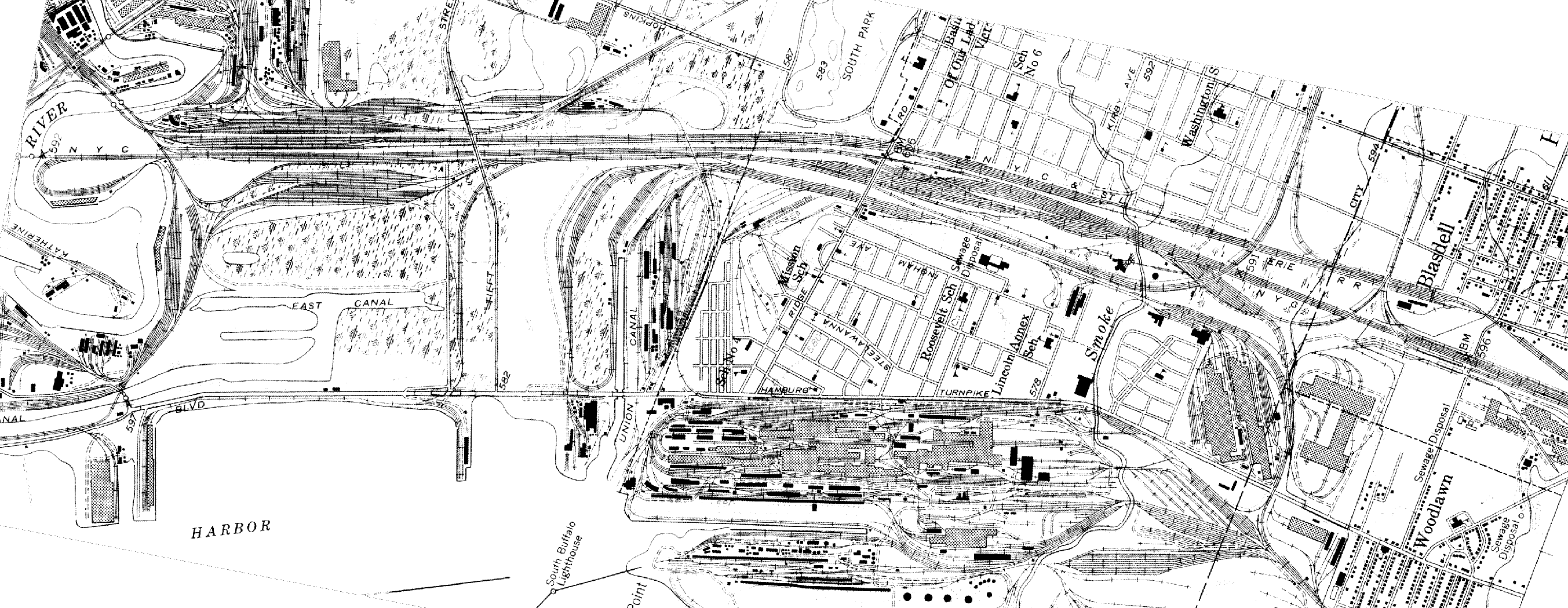
The South Buffalo, Lackawanna and Blasdell area. This another one which is not easy to describe. For details on the right half of this map please see the description for South Buffalo Yard/Lackawanna, HERE At the lower left is the Buffalo Creek Ohio St. Yards and the Lehigh Valley Coal Docks. Bethlehem Steel's Lackawanna, NY plant and the South Buffalo Railway's trackage is at the lower right. Lehigh Valley's Tifft Yards are toward the middle left above "East Canal" adjacent to BC's yard. Above the Lehigh is the NYC then the Erie (Buffalo & Southwestern), then the Nickel Plate, then the B&O then the DL&W Abbott Rd. Yard. The NKP & BC Buffalo River bascule bridges are at the upper left. That area was known as Buffalo Junction and is now CP DRAW. It's obvious that South Buffalo/Lackawanna was a very busy place for railroading 50 years ago! About 15% of this trackage remains today. CSX, Buffalo Southern, NS and Buffalo and Pittsburgh westbound/southbound mains are still there although the B&P hasn't been used in a couple of years. The South Buffalo is still in business serving the remains of Bethlehem Steel and a Ford plant. image/gif, 2706x1050 (16c) File="lack50.gif" Size=366674 |
 |
1950 Western New York US Geological Survey Map
A very large map (1 meg) showing North Buffalo. Most of the interesting parts are described above for h-50.gif. This map shows the Erie and Lackawanna lines from their East Buffalo Yards swinging around from International Junction to Black Rock. The NYC Belt Line winds northwest through the east side of town from Central Terminal and their East Buffalo Yard to the Niagara Branch Connection at H Tower in Black Rock. H Tower was finally razed in 1998. image/jpeg, 1500x2283 (256c) File="norbuf50.jpg" Size=943955 |